
ACKMA EcoGuide Course and Workshop 2021 - Wellington, New South Wales
An ACKMA Online workshop was held on Saturday 23rd and Sunday 24th October at Wellington in New South Wales. This event was held via a Zoom meeting.
Below are a number of presentations presented at this meeting. They are listed in the order that they were presented.
PDF File - containing Presentation Abstract 1.2 Jodie Strickland Jenolan Caves - Resilience Presentation.pdf Snow, Fires, Flood, Pandemic and a Wedding
Jodie Strickland, Jenolan Caves
While the title reads like a good action movie/romantic comedy, this presentation will give you a look at the forces that shaped 2019/2020 for Jenolan Caves. You will be taken through the natural disasters Jenolan had to manage in 2019/2020 including a record snowfall event, bushfires, a "1 in 100" year flood and the global pandemic that continues to impact us all. The presentation will provide you with an insight into how we managed the emergencies and recovery, as well as a personal perspective on resilience.
2.1 Ian Eddison Floods. drought and the circle of life.pdf Floods, drought and the circle of life in the Central West of NSW, Australia.
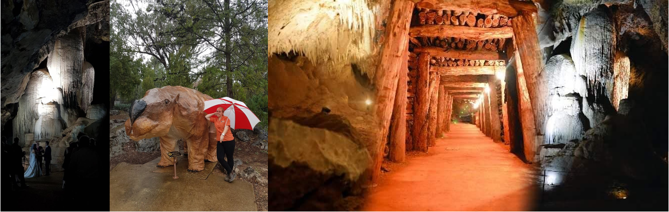
Ian Eddison, Caves Engagement Officer, Wellington Caves
The central west slopes and plains of NSW is home to the Wellington Caves, where evidence of Australia's megafauna were first found in 1830. Wellington Caves were not directly impacted by bushfires thankfully, but the drought which parched the South East of Australia to the point vegetation had become a tinderbox certainly did have its impact. This presentation shows the floods of 2016 through to the drought of 2019, the dust storms and the perilous life for some of our wildlife. This presentation is a snapshot of the last five years. It shows a circle of life through floods and drought which when the rain once again arrived in 2020, it carried the remains of current day animal species and deposited them at will throughout the landscape. We take a look at the affects of returning rains, the subsequent regrowth of vegetation and the life that came from that abundance of food. We watched the predation within the food chain and had some very interesting interactions with wildlife in our office and on our tours at Wellington Caves.
The last 5 years are only a blink of the eye in time. We are being told of the likely affects of human induced climate change are a warming planet and extreme weather events. It would seem we are prone to some very6 extreme weather events and they are occurring closer together. If that is correct, the flora and fauna that can respond the quickest when favourable conditions occur will continue to flourish and the species slow to respond may well be on a perilous path of survival.
2.2 Scott Melton Jenolan Caves 2021.pdf Trials and Tribulations - Jenolan Caves 2019 - 2021
Scott Melton, Senior Guide, Jenolan Caves
Jenolan Caves, located approximately 180 kilometres west of Sydney in the world heritage listed Blue Mountains, are perhaps the best known and up until late 2019, the most frequently visited show cave complex in Australia; regularly hosting nearly 240,000 cave visits per year. However, a series of events since December 2019 which have included bushfire, two major floods and their aftermath and the ongoing effects of the worldwide corona virus pandemic have all had an impact on Jenolan's operating model.
This presentation will provide a useful overview of Jenolan Caves to those who have not yet visited Jenolan Caves (and a refresh for others) including a focus on Jenolan's famous show cave tours. It will then document the aftereffects of the natural disasters, particularly on access to Jenolan Caves, along with some comments about the current model that Jenolan Caves is operating under. It should be noted however, that this presentation was prepared prior to the current lock down restrictions being introduced in NSW.
2.4 Dave Gillieson Kangaroo Island bushfires.pdf Effects of bushfires on karst, Kangaroo Island, South Australia
David Gillieson, School of Geography, Earth and Atmospheric Sciences, University of Melbourne
Kangaroo Island (KI) is a large continental island close to the South Australia coast, south of Adelaide. About 16% of the island is Late Pleistocene dune limestone, with small areas of Late Eocene to Late Oligocene limestone as well. Many karst areas on the western half of the island were burnt in late 2019 and early 2020. At Kelly Hill Conservation Park almost the entire area was burnt, including all above-ground infrastructure. Fire intensities were high resulting in widespread spalling of limestone outcrops, baking of soil and washing of soil and charcoal into closed depressions and cave entrances, following intense rainfall of 60mm in late January. A Friends of the Karst group has been formed with support from SA Parks Service, and frequent field trips are using LIDAR and drone imagery to document and map existing and new caves. The group is also having input to a new Western KI Parks management plan, and will also develop KI geotrails with an interpretive app in several languages.
3.4 Katrina Wills Sixteen Legs Exhibition and Documentary.pdf Sixteen Legs
Katrina Wills, Sixteen Legs/Bookend Trust
SIXTEEN LEGS is an exhibition and documentary about caves, cave biology and exploration and discovery in the underground world. The project showcases the results of over 30 years of scientific research, over 7 years of filming, and hundreds of millions of years of evolution from the break-up of Gondwana to the present day! In 2021, we have re-commenced our National Tour with assistance from the Australian Government's Visions of Australia program and other generous sponsors. Starting in Queensland, our main goal has been to provide regional and remote areas with an equal opportunity to experience a project that has previously toured to the capitals. The outcomes to date have been strong and enthusiastic responses from those regional communities. While environmental messages are often doom & gloom, this is an inventive and inspiring connection to an ancient natural world. The project aims to be more than just a visiting display by promoting community involvement as part of the Exhibition itself. This is an opportunity for regional artists to be involved in the ongoing interpretation of an unusual and beautiful Australian world alongside the creative mind and popular appeal of author Neil Gaiman.
Across Australia there is declining engagement with education and science, and our aim is to help inspire and reverse that trend. We're engaging a wide cross-section of the community and students of all ages and in the process providing an insight into the world of caves and cave conservation. Over six months to date, well over 5,000 people have visited the exhibition in regional areas , with many also viewing special screenings of the documentary. They have delved into real and fantasy representations of a world that most may never experience first-hand, but which may also inspire them to reach out and engage with nature in their own backyards.
4.1 Garry Smith Bullita - Australia's largest Cave system (ACKMA)V3.zip For ACKMA Members Only - Password Required
Australia's Largest Cave Systems in Judbarra-Gregory National Park, NT
Garry K. Smith, President - Newcastle and Hunter Valley Speleological Society
Dedicated teams of cavers making up the 'Judbarra-Gregory Karst Research Special Interest Group', have been undertaking annual pilgrimages to Bullita for the last 32 years to explore, survey and document the vast cave systems. The total length of surveyed passage reached 320km in 2020 and the expedition this year has probably added another 10km or more.
The Judbarra-Gregory karst covers an area about 30 km long by a maximum width of 1 km, but generally only a few hundred metres wide. It is a substantial area by Australian standards. The extensive multi level maze cave system has been created in Proterozoic dolomitic limestone. On the surface stromatolites domes created by microscopic photosynthetic organisms (cyanobacteria) some 1.6 to 1.0 billion years ago, are visible where the cap rocks have eroded away. These layered structures, up to 15 metres in diameter, can even be seen on images taken from orbiting satellites.
Among the largest chambers are; Mega Chamber 1 (107 m long x 24 m wide x 14 m high), Mega Chamber 2 (103 m long x 15 m wide x 15 m high) and the Giga Chamber (140 m long x 54 m wide x 7.4 m high) Above ground scenery is stunning with massive deciduous boab trees (Adansonia gregorii) scattered across the landscape and huge areas of tower karst, with razor sharp fluting. Bullita Cave System in the Central karst block has over 126 km of continuous surveyed passage, making it presently the 18th longest cave in the world. The Prometheus System in the southern karst block, which includes North and South Prometheus, Claymore, Two Fishes, and Atlantis caves, is over 57 km. The Dingo System of the northern karst has approximately 65 km of passage.
4.2 Andy Baker Wellington Recharge ACKMA.pdf Climatic, hydrological and karst geological controls on groundwater recharge: the view from an Australian vadose zone cave observatory.
Andy Baker1, Romane Berthelin2, Andreas J Hartmann2 and Pauline Clare Treble3,
(1) University of New South Wales, School of Biological, Earth and Environmental Sciences, Sydney, NSW, Australia,
(2) University of Freiburg, Chair of Hydrological Modeling and Water Resources, Freiburg, Germany,
(3) Australian Nuclear Science and Technology Organization, Kirrawee, NSW, AustraliaIn water-limited environments, quantifying the timing and frequency of erratic rainfall recharge events and its climate forcing is of critical importance for groundwater resource management. In temperate semi-arid New South Wales, SE Australia (precipitation: 615 mm/year, pan evaporation: 1679 mm/year), since 2010 we have been using a limestone cave situated at 20 m below land surface, and just above the water table, as a vadose zone observatory of potential recharge approximated by drip rate observations. Complimented since 2018 by a soil moisture probe network and using the VarKarst karst-specialized recharge model, we investigate the climatic, hydrological and karst geological controls on recharge dynamics. We observe nineteen recharge events (07.2010 to 01.2021). They cluster into two periods (1) seven events between 08.2010 and 12.2010 during a La Niña (enhanced spring rainfall is typical in eastern Australia) and (2) seven events between 06.2016 and 10.2016 associated with a negative Indian Ocean Dipole (which is associated with wet winters and springs in southern Australia). Comparison with antecedent rainfall indicates a minimum of 40 mm rainfall over 14- days is required for recharge in winter, and >120 mm rainfall over 14-days in summer. We will use the karst recharge model to simulate the observed recharge events and to quantify the threshold behavior of the soil and vadose zone above the cave. Two recharge events have occurred since the establishment of the soil moisture network (03.05.2020, 29.07.2020). For those, we can analyze the influence of antecedent soil storage on the initiation of recharge and use this understanding for an evaluation of the simulated internal fluxes and storages of karst recharge model. Providing realistic results of both recharge and soil moisture observations, the model can be used as tool to10 predict the impact of past and future climate changes on groundwater renewal.
5.2 Tim Stokes Tourist Caves of BC.pdf Tourist Caves in British Columbia - Why so few 'Show Caves' and are they needed?
Tim Stokes, Vancouver Island University, Fifth St., Nanaimo, BC, V9R 5S5. tim.stokes@viu.ca
Paul Griffiths, 544 Springbok Road, Campbell River, British Columbia, Canada, V9W 8A2. pgriff@shaw.caThe Canadian province of British Columbia (BC) has nearly 2000 documented caves in its land area of approximately 950,000 km2. Yet, there are no true 'show caves' with commercial tours and in-cave infrastructure (e.g., walkways and/or stairs). Horne Lake Caves on Vancouver Island and Cody Caves in the Interior of the province have tours-for-pay with some very limited infrastructure and no fixed artificial lighting. The caves are in legislated parks and private contractors to the park authority offer cave tours for a fee. Each cave has a range of family guided tours and adventure tours. Horne Lake Caves also offers a self-guided karst trail loop and self-guided access to small caves or cave segments. The demand for other show caves is likely present based on the number of visitors who explore the province's natural outdoors every year. Possible reasons for the lack of show caves include land ownership issues (many karst areas occur in public lands), distance from population centres and paved road access, a short history of cave tourism, and the ever-rising insurance and operating costs. It is likely that some caves could be developed as show caves in the future, but is that the right approach? Some pros and cons of show cave development in BC will be discussed.
5.4 Eddison Spate Gillieson ACKMA Conservation Actions.pdf What has ACKMA been doing over the past few years conservation-wise?
Andy Spate1, Dave Gillieson2 and Ian Eddison3
(1) Optimal Karst Management (2) University of Melbourne (3) Wellington Caves
ACKMA produces a quarterly Journal, the ackma@ackma.org mailing list and a website www.ackma.org to provide information to members. But have we told you about ACKMA's conservation and karst management13 efforts? Over the past few years ACKMA has contributed submissions, expert opinion and discussion on the following issues:
Our presentation will briefly discuss some of these issues where we have made submissions and contributed expert opinions.
- Cammoweal Caves degradation,
- Pilbara caves put under threat by Fortescue Metals Group WA
- Hills of Gold wind farm renewable energy proposal near Timor Caves NSW
- Juukan Gorge caves destruction by Rio Tinto
- Kangaroo Island Re-imagining Western National Parks and Management Plan
- Kosciuszko National Park - revision to Plan of Management issues
- Mole Creek abattoir
- Mt Etna quarry extension
- Mulu WHA oil palm plantation proposal
- Nullarbor 'green' energy proposals
- Pinagrealan Cave and nearby quarry blasting in the Philippines
- SA Parliamentary Inquiry into Aboriginal Heritage Act 1988
- Yarrangobilly Precinct Plan and Mountain Bike Track proposals
- Kosciuszko National Park Special Activation Plan
- Submission to the New Zealand Government regarding trade in materials such as sub-fossils from caves
- Kosciuszko NP feral horse management issues
6.2 Diana Fusco Vertebrate palaeoecolology Cathedral Cave Wellington Caves.pdf The vertebrate palaeoecology of Cathedral Cave, Wellington Caves.
Diana A. Fusco1, Lee J. Arnold2, Grant A. Gully1, Gavin J. Prideaux1
1College of Science and Engineering, Flinders University, Bedford Park, South Australia.
2School of Physical Sciences, Environment Institute, and Institute for Photonics and Advanced Sensing (IPAS), University of Adelaide, North Terrace Campus, Adelaide, SA, 5005, Australia
The Wellington Caves are one of Australia's most significant palaeontological localities. In 1830, fossils from the Wellington Caves gave the scientific world its first glimpse into the rich prehistory of Australia's fauna. Indigenous people had been on country for millennia, but to the rest of the world, Australia was a new and unexplored place. Its fauna was unexpected, unlike anything previously known, and its extinct fauna was even stranger. Large quantities of fossils have been collected from these caves in the years that followed, but provenance, chronology and stratigraphic context is commonly lacking. Overall, relatively little has been published on the Wellington Caves fauna following the early interest in its extinct megafauna and the locality remains underutilised and poorly understood. However, what these collections did reveal was the capacity of Wellington Caves for investigating fundamental questions regarding the late Quaternary fauna and environment of Australia. During the late Pleistocene 129 - 11.7 kyr (thousand years) ago, Australia saw the loss of >90% of its large terrestrial vertebrate species and the assembly of modern faunal communities. Much debate has focused on the relative roles that humans and climatic change played in shaping these assemblages. To investigate faunal responses to environmental change, Flinders University commenced a new excavation in 2016 at the Wellington Caves in the main chamber of Cathedral Cave. Excavations have so far reached a depth of 5 m below the surface of the sediment floor. Our work has revealed that Cathedral Cave contains the most diverse late Pleistocene mammal deposit yet known in Australia. Our investigations have utilised methods of stratigraphy, radiocarbon dating, optically stimulated luminescence dating, and palaeoecology, to shine new light on the late Pleistocene fauna and the changing environment in which it lived.
7.2 Kyung Sik 2021-10-ACKMA.pdf Justification for the new IUCN program (Key Geoheritage Areas) for geoheritage conservation in the world.
Kyung-Sik Woo, Professor Emeritus, Department of Geology, Kangwon National University, Chuncheon, Gangwondo 24341, Republic of Korea; Chair, IUCN WCPA Geoheritage Specialist Group
Geoheritage can be categorized into local, national, and international values and needs to be conserved for future generations because geoheritage sites contain significant evidence for the history of the Earth and the evolution of life, as well as ongoing geological and geomorphic processes. Conservation of geoheritage sites should be justified because they cannot be restored once damaged. Thus, it is necessary to establish legal protection and effective management of these sites in each country. Unfortunately, the necessity for the conservation of geoheritage is not yet sufficiently recognized at national and international levels, compared to ecological and biodiversity values. So far, there is no initiative to promote geoheritage management under international nature conservation policies. Despite the UNESCO's international designations (World Heritage Sites and Global Geoparks) that recognise geoheritage, too many potential geosites representing the 4.6 billion years of the Earth history and evolution of life have been neglected and have been being destroyed. Therefore, a new programme in IUCN - Key Geoheritage Area (KGA) - has been suggested past three years, correspondent to the Key Biodiversity Areas already running. The KGA should be primarily based on the scientific value of geological features alone. For an effective KGA designation, objective geological contexts with appropriate criteria should be developed based on representativeness, rarity, and integrity. The KGA is a proposal that is being worked inside the WCPA's Geoheritage Specialist Group (IUCN) but it will need the collaboration of other relevant organisations such as IUGS, ProGEO, IAG and UIS toward its full adoption by IUCN. Caves and karst will be a significant part of this program.
7.3 Nick Powe ABIS UK 2021.pdf The Association of British and Irish Showcaves (ABIS)
Nick Powe, Member of ABIS, Director of Kents Cavern Prehistoric Caves, Torquay, United Kingdom Email: nickpowe@kents-cavern.co.uk
The Association of British and Irish Showcaves (ABIS) was established in 1989 bringing together the main showcave operators in Britain. At the time it was called The British Association of Showcaves (BAS). In 2001 the Association was expanded to include leading showcaves in Ireland and the current name was adopted. Members operate naturally occurring caves, controlling public access underground without the need for16 specialist equipment. All ABIS showcaves endeavour to protect the natural environment. They provide safe access for visitors and study groups to experience not only the visual side of the fantastic rock formations that have been created over millions of years but also the sense of history that exists underground. This oral presentation gives an insight into the members and highlights common issues experienced in the last few years.
Membership:
Please note and share to potential new members www.ackma.org/membership.html